
Author Archives: geolab
The PEI Comprehensive Development Plan: A Timeline
The signing of the Comprehensive Development Plan (CDP) in 1969 was one of the most influential events in the modernization of Prince Edward Island. The developmental plan offered wide-sweeping changes to the island’s economy, infrastructure, and education that still affect the province to this day.
Here at the GeoREACH laboratory, it is one of our goals to help others understand how exactly the CDP affected life on the Island, both in the past and today. For this reason, we have created a full, comprehensive timeline of the CDP, from the events leading to the CDP’s formation to its eventual conclusion in 1984. We hope that it is helpful in understanding this significant time period. Enjoy!

Mapping Land Use on PEI in the 1960s
by Choyce Chappell, UPEI
29 May, 2019
The poster that I produced at the UPEI GeoREACH Lab in the 2019 winter semester offers a unique glimpse into PEI’s past. Nick Scott, another GeoREACH lab member, found and scanned a map detailing the approximate property boundaries of almost all of PEI in the 1960s. We called this map the Beaulieu Map, after Andrée Beaulieu, a federal researcher with the Department of Energy, Mines and Resources. The Beaulieu map was based on aerial photos from the early 1960s, so while the plot sizes were not exactly accurate, they were extremely close for a hand-drawn map. This was a fascinating find. The map was created to support the Comprehensive Development Plan (CDP), one of the central research subjects of Dr. MacFadyen’s GeoREACH Lab at UPEI.

I began this part of the project began by exploring avenues to try and use processes that would automatically digitize the map into a format that would work with the GIS softwares that the lab uses. Unfortunately, due a number of factors, such as limitations with GIS tools, creases in the map from folding, and inaccuracies in the map, we were unable to do so. As a result, I switched over to sampling six townships, and manually digitizing them. The result initially contained small errors in geometry, so we tried to minimize those using several GIS tools and by excluding slivers and small parcels from the analysis.
Getting the poster and preliminary analysis ready the Environmental Science Atlantic Conference was a real time crunch, and the first version of the poster had little quantitative data and little in the way of visual supplements. Over the following few weeks, the final poster (see above) was refined and presented to members of the GeoREACH Lab and other members of the UPEI community. I added added and rearranged new information, I completed additional quantitative analysis, and I added and edited more images to accurately reflect the research process and the story we uncovered.

To perform the quantitative analysis, we categorized properties by the size of the parcel (a smallest size, three mid-sizes, and a largest size), and analysed land use by five dominant categories (cleared land, forested land, harvested clear-cuts; harvested partial cuts; and reverting land). Using this data, we were able to make some generalizations about ongoing trends among farms according to their property size, location, and land use. This is a unique glimpse into the lives of Prince Edward Islanders in the 1960s, finding many stories that could not have been told with other forms of historical analysis.
The true success of this work is knowing how much further it can go, and what it means for the future. This work is preliminary to digitizing the whole map, and can be used as a template for such a project. Additionally, the work can be used to see how much the CDP affected the land use and cover change, and the soil quality, of PEI over time, or to analyse the land use of properties by water shed, county, topographic features, and more. Even though I am no longer with them, I’m excited to see what the GeoREACH lab does with this work!

Meet the UPEI GeoREACH Lab
by Alex MacIsaac, Applied Communications, Leadership & Culture, UPEI. Originally posted on the ACLC website.
This article is first in a two-part series by ACLC student Alex MacIsaac on the kinds of skills and opportunities ACLC emphasizes through its courses, extracurricular activities, work experiences, work-integrated practicums, and experiential projects. This series focuses on digital mapping opportunities in the context of ACLC faculty research projects.

The GeoREACH Lab team, March 2019. Photo by A. MacIsaac
The GeoREACH Lab at UPEI supports Geospatial Research in Atlantic Canadian History and other projects of the Applied Communications, Leadership & Culture program at UPEI. Dr. Josh MacFadyen is the director of the GeoREACH Lab, and working under him, a team of students are researching the environmental history and historical geography of Atlantic Canada. Much of their work focuses on the history of food and agriculture in Canada, including the ways that the modern food system has shaped our relationships with animals and the land. The transition to this kind of system occurred relatively recently on PEI, and this presents an opportunity to map the causes and impacts of the transition using the tools of the geospatial humanities.
A geographic information system (GIS for short) is one of these geospatial tools. A GIS is a system designed to capture, store, manipulate, analyze, manage, and present spatial or geographic data. The members of the GeoREACH Lab utilize GIS in order to visualize, compare, and analyze historical data. Much of this research involves mapping the region’s human and non-human inhabitants using GIS.
The lab’s work supports training in the ACLC program, but it is also open to students and researchers in other disciplines. For instance, Julianna Granzoti and Catherine Kennedy are both Environmental Studies students at UPEI. Julianna and Catherine have worked together in the past, and they collaborate in their work with the GeoREACH Lab. The central aspect of their research revolves around geographic changes over time on Prince Edward Island between 1968 and 2010. Some of the lab’s current projects focus on the impact that policies like the 1969 Comprehensive Development Plan had on communities and the land. Julianna and Catherine are able to observe and analyze many aspects of the local environment over different time periods through using GIS programs. Students view different “layers” of maps in order to compare and contrast environmental changes over time.

“In environmental studies it’s really interdisciplinary, so we need to look at the science side and the social side, and I think GIS helps fill a gap with that because we can visually try to analyze what we’re seeing, say look at nutrients in soil for example, but we can also find the history of the area. I think (the technology) could be applied to many different disciplines.”
–Catherine Kennedy
Andrew Ing, a Geomatics Supervisor who works with the province of PEI in the Forest, Fish, and Wildlife division, visited the lab to show student researchers the many layers of GIS maps the province is creating, and why they are particularly important. At the provincial level, GIS data layers are being created and analyzed often. A variety of GIS data related to property, infrastructure, and natural resources are available in some cases for free, and others for a fee from the Government of Prince Edward Island. Government agencies and other researchers have been developing GIS-ready data since the 1960s. This presents a new opportunity to researchers like Dr. MacFadyen who are interested in studying changes in the land in this critical period of environmental history.

“For the purpose of research, it’s easier and faster (to use GIS maps).”
–Julianna Granzoti
Choyce Chappell is in her 5th year of study at UPEI. She is completing a major in Environmental Studies with a specialty in thought and practice, and minors in Diversity and Social Justice Studies and Computer Science. Although Choyce said that geography was never an interest to her until a special topics course, Introduction to GIS, sparked her interest. Through GIS, she believes she can bring her diverse interests together. Choyce is completing a directed studies course in GIS for Humanities Research with Dr. MacFadyen at the GeoREACH Lab. This means through working at the lab she is completing an upper year university credit.
Choyce has used GIS programs, namely ArcGIS and QGIS, to digitize maps in order to turn flat images into interactive layers. This allows Choyce and other researchers to plot data and compare environmental topics on the island.

“I found using GIS could put me in the middle of the Liberal Arts, the humanities, social sciences, natural sciences, and computational sciences. I thought it was a good way to bring all of my really diverse interests together.”
–Choyce Chappell
“There are different ways of representing data other than in writing” explains Nick Scott, a History student in his final year of study at UPEI. Nick describes himself as one of the GeoREACH Lab’s “explorers”; one of his main duties involves summarizing different historical primary sources so that other students can use them for various projects. He aides the other student researchers in locating particular areas to study and documents of interest so they can proceed with their projects. Nick has a knowledge of PEI’s social history and local geography, which helps him guide other lab members to locations or topics he can recognize as important research areas.
“In this job, there’s been a lot of freedom for different students to utilize their different backgrounds and skills in ways that are useful to the projects.”
–Nick Scott
For more information on the GeoREACH Lab, visit the GeoREACH website at UPEI.
Welcome to the GeoREACH Lab Website

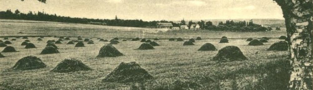
Land Use in Wheatley River, PEI (1935)
Welcome! The GeoREACH Lab supports Geospatial Research in Atlantic Canadian History and other projects of the Applied, Communications, Leadership & Culture program in the Faculty of Arts at University of Prince Edward Island (UPEI). The lab is directed by Dr. Josh MacFadyen, an environmental historian and Canada Research Chair in Geospatial Humanities at UPEI.
The Lab’s current projects focus on the history of food and agriculture in Canada, and we study the ways that the modern food system has shaped our relationships with animals and the land. Prince Edward Island was a relative late adapter of modern industrial agriculture, and in many ways it is still going through this profound social-ecological transition. This presents an opportunity to interview, map, and otherwise study the causes and impacts of agro-ecosystem transformation in one place over time.
We hope you will check out the About page keep watching this site for ongoing information on the research we are doing at UPEI.