

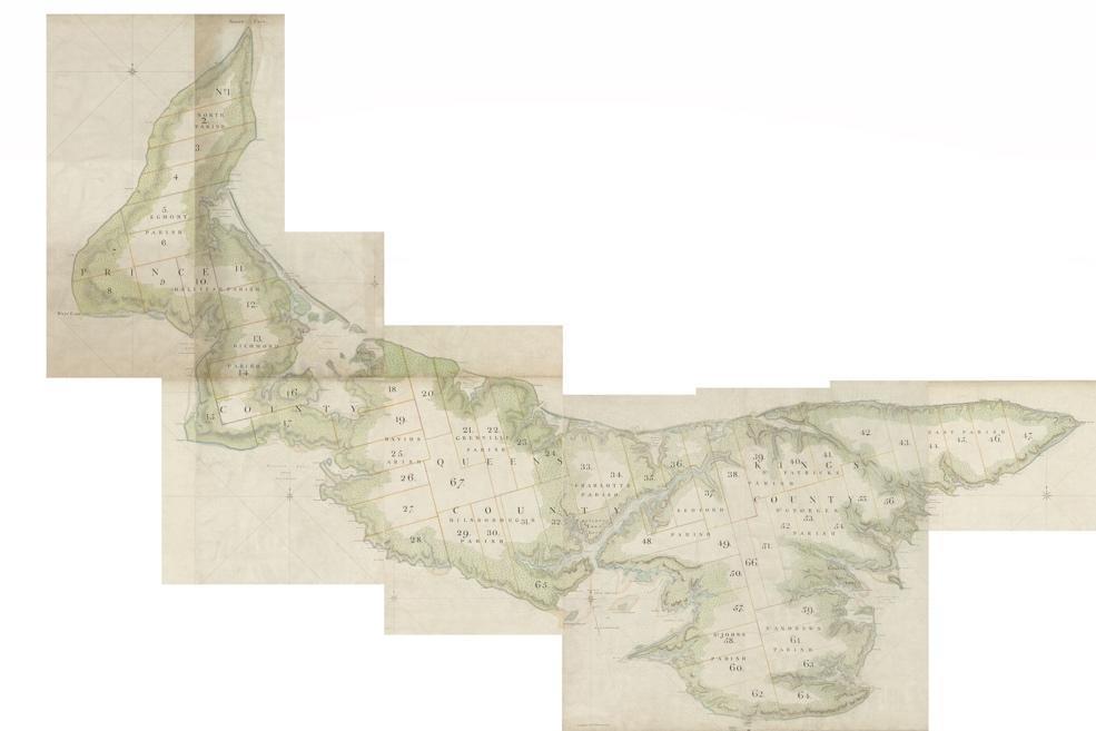
1765 Holland Survey. Key map in PEI history, (mostly) accurate survey of the Island with assigned placenames and division into “Lots”. Includes land coverage details along coasts and estuaries, and overall remarks. For more details, see Lockerby & Sobey (2015).
Original maps are held/digitized by Library and Archives Canada in multiple sheets, but georeferenced versions may be found on GeoPEI.
Bibliography entry:
Holland, Samuel and Charles Pettigrew. A Plan of the Island of St. John in the province of Nova Scotia. 1765. Map. Library and Archives Canada. http://central.bac-lac.gc.ca/.redirect?app=fonandcol&id=4125301&lang=eng
Image acknowledgement:
Map Source: GeoPEI: The Prince Edward Island Historical Map Viewer, a web application of the UPEI lab for Geospatial Research in Atlantic Canadian History (GeoREACH Lab) ,
https://experience.arcgis.com/experience/9870ec990eaa40069f772b7025fbd18c/
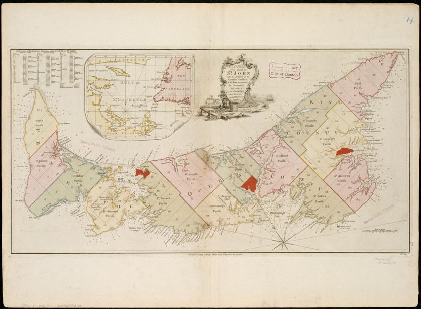
1775 Samuel Holland. Map updated with new settlements, planned roads, and soundings along coasts and harbours (not resurveyed).
Bibliography entry:
Holland, Samuel, and Andrew Dury. A plan of the island of St. John. 1775. Map. Norman B. Leventhal Map & Education Center. https://collections.leventhalmap.org/search/commonwealth:6t053n77m. [Access date].
Image acknowledgement:
Map reproduction courtesy of the Norman B. Leventhal Map & Education Center at the Boston Public Library, https://collections.leventhalmap.org/search/commonwealth:6t053n77m
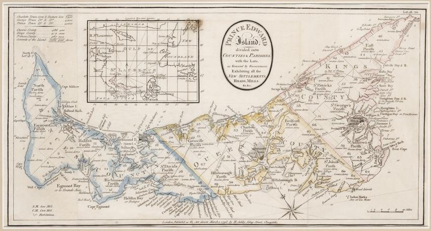
1798 Ashby map. After Holland 1765 survey, but updated with roads and communities.
Bibliography entry:
Ashby, H. Prince Edward Island divided into Counties & Parishes. London, 1798. Map. Island Imagined, Robertson Library, UPEI.
Image acknowledgement:
Map source: UPEI Island Imagined, https://www.islandimagined.ca/islandora/object/imagined:16
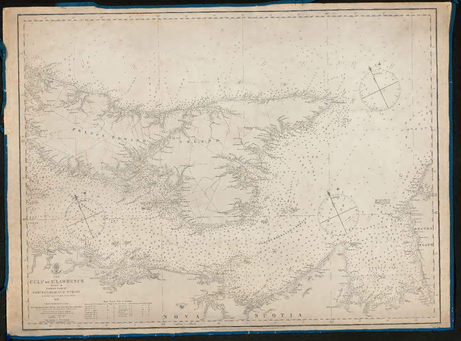
Bayfield Charts, 1840s. Thorough naval surveys performed in the mid-19th century, showing soundings, lighthouses, churches.
For more information, see the two volume set of Bayfield’s journals in the Champlain Society series (see link at the bottom of each page to download the full PDFs):
Ruth McKenzie, ed., The St. Lawrence survey journals of Captain Henry Wolsey Bayfield, vol. I (Toronto: The Champlain Society, 1984), https://collections.mun.ca/digital/collection/cns/id/60577/rec/1
Ruth McKenzie, ed., The St. Lawrence survey journals of Captain Henry Wolsey Bayfield, vol. II (Toronto: The Champlain Society, 1986), https://collections.mun.ca/digital/collection/cns/id/50465/rec/1
The Bayfield maps relevant to PEI have been georeferenced in GeoPEI: PEI Historical Maps, Geospatial Research in Atlantic Canadian History, The GeoREACH Lab, UPEI.
https://experience.arcgis.com/experience/9870ec990eaa40069f772b7025fbd18c/
The larger set of Bayfield’s charts were originally catalogued by McGill University Library. They are now accessible through the Internet Archive in varying levels of detail – if harbour or bay does not have its own chart (e.g. St. Peters Bay), refer to larger eastern and western Northumberland Strait Charts.
For the full list at McGill Library see “Bayfield Charts Collection.” https://www.library.mcgill.ca/hostedjournals/bayfield.html. Note the “Manuscript index to 167 Bayfield Charts” hand written index dating to 1931. https://archive.org/details/McGillLibrary-rbsc_map_bayfield-000-index-18873
Eastern Northumberland Strait:
https://archive.org/details/McGillLibrary-rbsc_map_bayfield-034-18915
Western Northumberland Strait:
https://archive.org/details/McGillLibrary-rbsc_map_bayfield-033-18914
Bedeque Harbour: https://archive.org/details/McGillLibrary-rbsc_map_bayfield-074-19227
Cascumpeque Harbour: https://archive.org/details/McGillLibrary-rbsc_map_bayfield-066-19169
Charlottetown Harbour: https://archive.org/details/McGillLibrary-rbsc_map_bayfield-072-19176
Cardigan Bay: https://archive.org/details/McGillLibrary-rbsc_map_bayfield-068-19171
Murray Harbour: https://archive.org/details/McGillLibrary-rbsc_map_bayfield-070-19175
New London Bay https://archive.org/details/McGillLibrary-rbsc_map_bayfield-067-19170
Bibliography entry (example):
Bayfield, Henry W. The Gulf of St. Lawrence. Sheet IX, Eastern Part of Northumberland Strait. London: Hydrographic Office of the Admiralty, 1845. Nautical Chart. McGill University Library.
Image acknowledgement:
Source: https://archive.org/details/McGillLibrary-rbsc_map_bayfield-034-18915, courtesy Digitization McGill.
George Wright, 1852, as based on Bayfield charts and recent surveys. More detail than Bayfield charts inland, including names of Lot owners.
George Wright Jr. was the 5th and last generation of Wrights to hold the position of Surveyor General, from Thomas (part of the Holland Survey) to Charles to Charles to George Sr. to George Jr.
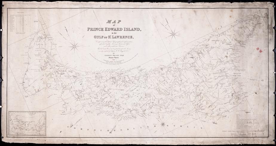
There were several markups on the PARO copy (link on Island Imagined, below) likely by Henry Cundall prior to 1859, according to Reg Porter. https://regporter.com/pei/2021/05/26/the-cundall-and-wright-maps-of-1851-61-the-birth-of-island-cartography/. Even Estuaries were added, e.g. at the east end of Tracadie Bay, that were later added to maps such as Cundall’s 1861 and 1903.
Bibliography entry:
Wright, George. Map of Prince Edward Island, in the Gulf of St. Lawrence. Charlottetown: Surveyor General’s Office, 1852. Map. PEI Archives and Records Office, 1169.
Image acknowledgement:
Map source (PARO’s copy): UPEI Island Imagined, https://islandimagined.ca/islandora/object/imagined%3A209164
1863 Lake map, paid for by subscription. Also based on Bayfield surveys, with additional detail including inserts of cities and towns.
The brown original, digitized by UPEI (46MB file), can be found at https://islandimagined.ca/islandora/object/imagined%3A208687
The Island Register has also created an index of the individual lot maps: https://www.islandregister.com/lakem/1863maps.html
A slightly brighter version, split over 6 pages, can be found at: http://central.bac-lac.gc.ca/.redirect?app=fonandcol&id=3976436&lang=eng.
The best complete, cleaned copy is found on Reg Porter’s blog: https://regporter.com/pei/2021/07/01/the-lake-map-of-1863/
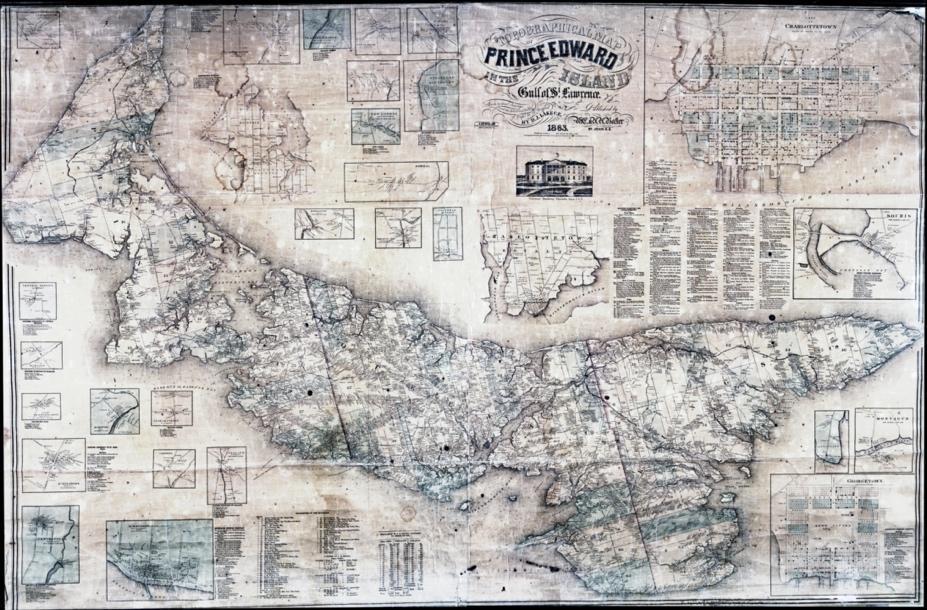
Bibliography entry:
Lake, D.J. Topographical Map of Prince Edward Island, in the Gulf of St. Lawrence. St. John, NB: W.E. and H.H. Baker, 1863. Map. Island Imagined, Robertson Library, UPEI.
Image acknowledgement:
Courtesy Reg Porter, https://regporter.com/pei/2021/07/01/the-lake-map-of-1863/
Lot Surveys. Individual surveys in varying condition can be found on the Island Imagined website for many of the lots during this time period. Additional surveys and maps that have not been digitized can be found in the Public Archives and Records Office via the map index drawer.
Note that there is no date on the following example, but by comparing it to the Holland survey and subsequent historical development of the lots displayed, it can be dated circa 1800.

Bibliography entry
Anonymous. Plan of Lots 38, 39, 40, 41, 42, 66 and part of Lot 43. N.d. PEI Archives and Records Office, 1048.
Island Imagined, Robertson Library, UPEI.
Image acknowledgement
Map source: UPEI Island Imagined, https://islandimagined.ca/islandora/object/imagined%3A209064