“There is no crop on your farm which can so ill bear delay at this time as your turnips, and unless you can afford to throw away the labour you have expended, and to forgo the benefit of a good supply of turnips for your stock, do this when it should be done, and do it well. If you are shorthanded, get every man woman and child who can lift a hoe, or pull a weed, go to work in earnest, and the job will soon be accomplished; and what is more your children will become expert at turnip culture on which all successful farming in this island will before long depend: and remember that a good turnip hoer never takes his eyes from the ground until called to dinner; recollect this yourselves, and impress it on the children, and there will be no stopping to talk, nor ceasing work to gaze at every passerby, by which so much time is often lost.“
“During the past ten years the production of ranch mink in the United States and Canada has rapidly increased. Over four times as many mink are now raised on Canadian and American fur farms as ten years ago. From 1940-1945 the average yearly production in the United States and Canada was 525,000 and the estimated 1950 production is close to 2,000,000 in the United States and 350,000 or more in Canada. About ten years ago the first mutation mink made their appearance but in very small quantities, Standards being the vast majority of the pelts to reach the auction companies. Today the situation is different as more mutations were produced last season than the standard dark mink type. A number of these different colors have been popular with the trade and profitable to the breeders but some have not been a paying investment and have been bred at a loss.”
“Today was a wash spread to fitful sun and cloud; a mild wind of February, and a sheltered hillside baring; a lone wild duck on wing and a blue jay’s shrill call. It was children off bright and eager to school-by sleigh, and the farmers busy about at the choring and hauling. We saw a grist being taken to the mill, one which will vanish smartly in tins and handfuls to the mangers of the stables about.
“‘Next thing we know there’ll be lambs’ Mack, little fellow of the place came in with the news today. ‘Yes, shortly. Do you know we’re not too far from spring now? There’ll be more calves and kittens too!’ he remembered. ‘I hope’ he added soberly ‘we’ll have good luck with those.’
…
Sugar maple sap collection.
“And through the branches of the maples in the yard, the little breeze played, bringing us tales of a sap-time of young years we knew… of honey-combed March snow in an old woodland where odd sugar maples grew. Not far from the sweetest brook rippled its thawing tunes as between woodsy banks it emerged in a meadow and ran at length to the river and Strait. And the trees tapped and tended by the farmlands thus providing nectar for themselves and any wayfaring maids could not know how far apart the band would one day wander to visit and dwell in separate climes and places.”
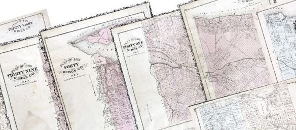
The Illustrated Historical Atlas of the Province of Prince Edward Island, colloquially known as Meacham’s Atlas of 1880, was one of the first attempts to map PEI in its entirety. A whole host of information can be found within the atlas; from detailed maps of each of the lots on the island – down to the individual houses, to realistic drawings of prominent citizens and their properties. It is a dream resource for any Island historian!
The Meacham’s Atlas maps before mosaicing.
For us at the GeoREACH lab, the atlas represents yet another opportunity to compile data on energy usage on the island during this period. We can see in the atlas the individual lots that compose our island even to today, each with personalized property information. The cartographers went so far as to outline the individual houses, barns, other infrastructure and property owners for each lot.
The Meacham’s Atlas maps after being mosaiced.
An important step in gathering the data from Meacham’s Atlas was to centralize all the available rasters (individual images) to a single resource. As all the lots were created independently, they would have to be stitched together into a single, geographically accurate map in a process formally known as mosaicing. This is why we have made, using GIS, a comprehensive mosaic of all the lots to easier represent this information.
The building points displayed over the entirety of Prince Edward Island.
Beyond that, we also entered data points for the over 16,000 buildings indicated on the map. Though it is still a work in progress, it is now available to be explored. You can adjust the different layers through the content window to look at churches, houses, mills, or schools, or can zoom in to a region you know well to see what it looked like in 1880!
The following is an excerpt from the Newsy Notes column by Agricola. The article, titled “Controversy over Fertilizers” was published in The Charlottetown Guardian newspaper on January 19th, 1946.
“Agriculture in Britain, given new life under the pressure of war, is engrossing the attention of the public as never before. One evidence of this is the interest taken in the wide-spread controversy between those farmers who favor the use of “artificial” fertilizers, and those who pin their faith on the old standby “muck”, which being translated is manure or dung.
“On the one hand, then, are those connected with “big business”- we have them in Canada too- who maintain that natural manures are not economic, that all farms should be run as factories, and that fences and horses should be scrapped in favor of prairies and tractors. On the other hand there are those who believe with Lord Lymington that “mineral and dung in solution, fused by human sweat, remain the food of civilized man.” They are also convinced that the use of artificial fertilizers is slowly poisoning the whole population, and have named sulphate of ammonia “Devil’s Dust.”
As far as we know, the 1940s were prior to the real industrialization of farming on Prince Edward Island and through much of Canada. Evidently, though, the debate on the development of large-scale operations was a heated one from the beginning. Ammonium sulphate is still a fairly widely used fertilizer across Canada today, despite its clearly long history of controversy and early nickname of “Devil’s Dust.” According to The Government of Canada (2020), 11 000 metric tonnes of Ammonium sulphate were in inventory in the September count in Atlantic Canada alone; this is a number that in actuality has increased since 2015.
“The last statement is a serious charge, and can only be proved or disproved by a series of experiments which must necessarily be lengthy. Something of the sort has been done in New Zealand, and the results were published in 1939.The locale of the experiment was the Mount Albert Grammar School hostel, which housed sixty boys and the teaching staff. The dietary of the hostel was far above the customary standard for boarding schools, yet the boys suffered- as was the case in other N.Z. institutions- from colds, catarrh, septic tonsils, influenza, dental caries, and other ailments. (It must be stated here that all New Zealand’s food supplies are grown by means of chemical fertilizers).
Picture of humus
“In 1936 Dr. G. B. Chapman of the Physical and Mental Welfare Society of N.Z. advised that the hostel’s fruit and vegetables be grown on properly prepared humus instead of chemically treated soil: and an acre of black volcanic soil was put under cultivation. No chemicals were used. The report of the matron of the hostel in 1939, said “The first thing to be noted, during the twelve months following the change-over to garden produce grown from our humus-treated soil, was the declining catarrhal condition among the boys. There was also a very marked decline in colds and influenza. Colds are now rare and any cases of influenza very mild. In the 1938 measles epidemic, which was universal in New Zealand, the new boys suffered the more acute form of attack: the boys who had been at the hostel for a year or more sustained milder attacks with a much more rapid convalescence.”
This influential study by Dr. Chapman was presented to the House Select Committee to Investigate the Use of Chemicals in Food Products in the United States Congress in 1951.
“There is much more to the same effect but we pass on to the Royal Commercial Travellers’ Schools near London, England. In 1939, Dr. E. Brodie Carpenter of that institution, took over the dental care of two or three hundred children whose condition he found “to be (dentally) deplorable.” In Sept. 1941, he again classified his charges and found the percentages of caries was about the same. In 1943 and 1944 there was some improvement, but the Dr. got a great surprise in Sept. 1945: his A class- the best- had increased to 97 per cent (from 50 p.c.); the B class once 32 p.c. was now only 3 per cent; and the C’s- worst of all, and once 18 p.c.- were entirely eliminated.
“Dr. Carpenter set out to find the reason for the improvement, and discovered that a 5 ½ acre field had been taken over in 1939, and a gardener appointed who believed in manure but not in fertilizer. He brought the field up gradually till the school was self-supporting so far as roots and green vegetables were concerned: and he claimed that the humus-grown stuff was responsible for the great improvement cited.
It is important to recognize that Dr. E. Brodie Carpenter was a dental scientist, but he was an active soil conservationist in the Soil Association’s group in Middlesex, England.
“At the College of St. Columba in Northern Ireland they even produce their own wheat and bread! Chemical fertilizers are rigidly excluded, and to this is attributed the very high standard of dental health enjoyed by the students.
“Now these conclusions are certainly plausible and seem to point the way to a change in farming, but it will, I venture to predict, take a long time to convince the farmer that he must farm without chemicals. Overwhelming proof that they are dangerous must be produced, and such proof will be hard to furnish: two or three examples are not enough.
“Chemical fertilizers certainly give the crops, and within certain limits the more fertilizer, the bigger the crop- which is all that the farmer looks for. But there are many chemicals in the soil in very small amounts, which are necessary to the good health of the crop and its consumer as well. The bigger the crop the more the soil is depleted of these necessary elements. We have already got to the stage where we must supply the turnips with boron and the potatoes with magnesia, while there may be other deficiencies not so apparent, or not yet discovered.
“A year or two ago P.E.I. was in the spot-light on account of the longevity of its people. Was the cause of the long life in the naturally raised food which the old-timers ate? Will the next generation live as long?”
The life expectancy in Canada has been steadily increasing over the course of the last century, according to the Government of Canada. So, while perhaps Agricola was a little too enthusiastic on suggesting artificial fertilizers as the cause of the early demise of Canadians, there is still value to noting that there were advocates for organic and sustainable farming in the 1940s, even though the concepts were not yet fully understood.