D. Bailey Clark: The Edge, Found
The following written work won third prize in the Joan & Regis Duffy Foundation Creative Non-Fiction category of the 2023 Island Literary Awards.
The Edge, Found
It’s 9:45 A.M. After entering Indian River, I turn off Route 20 into a narrow driveway, just wide enough for my car. On the left, a forest. On the right, I see my parents’ house and yard through what’s left of the line of spruce and pine trees that, until September 2022, blocked this view.
I reach a small clearing about a third of a hectare in size. To my right sits a white house. My neighbour, a man with grey hair on his head and face, greets me. I’m here to see what’s left of the old mill at the back of his property, and he is my guide.
A mill operated at this site for at least two hundred years. On his well-known map, Captain Samuel Holland recorded one here in the 1760s. Meacham’s Atlas of 1880 shows saw, shingle, and grist mills at this site. Collectively, the mills became known as the Tuplin Mill after the Tuplin family that operated them.
The mills here were once a central part of life for those living in the community. They provided lumber and shingles to construct houses, buildings, and churches in the surrounding area. Local farmers brought grain to the grist mill here to have it ground into flour for baking. My Dad remembers fishing in the mill pond as a kid. When the pond froze in winter, the Tuplins cut ice blocks, encased them with sawdust from the mill, and sold them to those in the community to keep their food cold throughout the summer.
The mill closed in the 1950s and began to fall into disrepair in the 1960s. The dam burst, and trees have reclaimed much of the area.
No longer useful, the mill—and the river itself—ceased to be a part of Islanders’ lives. Although I grew up next door, I’ve never seen the old mill, and I realized only recently that the stream running alongside my neighbour’s property—“the brook,” as my Dad calls it—is the Indian River, as in the name of the community where I grew up. I never consciously thought about the words “Indian” and “River.” Together, they formed a shape in my mind and only meant what they meant to me: home. I never associated “River” with, well, a river, nor did I associate “Indian” with the Island’s Indigenous population.
My guide leads the way into the woods behind his house. The trees block the sunlight and the wind. Our boots crunch in the snow as we step over fallen twigs, under tipped-over trunks resting against their neighbours, and through their dangling limbs waiting to scrape the soft skin of my face. My guide comments that reaching the old mill site has become difficult since September.
We arrive at the remnants of the dam, which slopes at a sixty-degree angle to our right. It is snow-covered, frozen earth standing about two metres above our heads, with fallen trees and brush on both the slope and the summit.
My eyes focus on what’s in front of me at the base of the dam. Rusted red iron rods about a metre in height stand at various angles facing each other in two rows, the wood they were supporting long gone. Square nuts are threaded onto their ends. I place my gloved hand on the tip of one of them, feeling the rod poking my palm softly.
My guide turns and starts to climb the dam. I follow. The brush hisses as it scrapes my jacket. I join my guide at the crest, where we look down through some branches to see the other side of the dam, a vast clearing about fifty metres deep and twenty-five wide: the site of the former lake. A few metres below us, the floor of the clearing is flat and mostly white, with clumps of faded yellow marsh grass half-buried every few metres. To our left, there is a break in the snow and a shallow stream.
We descend into the clearing, where the air is still, and walk toward the stream. The waterway is about two metres wide and a half-metre deep. The sunlight, no longer blocked by the trees, reaches through the water, illuminating a brown, muddy bottom. The current is slow, making a slight splashing sound. If you dropped a toy boat into this stream, you could catch it before it was out of reach.
My guide again leads the way as we follow the stream back toward the dam. We begin climbing about five metres from where we descended, the dense brush making its best effort to stop us. As we reach the summit, a louder splashing sound reaches my ears, coming from below us to the right. The lazy stream of the clearing has breached the dam and become white water tumbling over itself. The river remains shallow, but this is no place for toy boats.
We crawl through the brush and the trees back to my guide’s driveway.
It’s 11:20 A.M. I drive alongside the brook as it runs parallel to my neighbour’s driveway. I reach Route 20 and turn right, passing over the river in one of two places that it has been bridged.
To see the river again by car, I must take a detour. I drive along Route 20, past fields and forests, for about a kilometre. My studded tires roar on the asphalt. I turn left onto the Hamilton Road and drive almost two-and-a-half more kilometres past more fields and forests. I turn left onto the MacLellan Road, and then left again onto the Easter Road. The road angles to the right and leads to the shore. After making this square-shaped detour, I don’t intuitively sense that the water I am looking at is coming from the same source as the mill site. But it is.
About eight hundred metres before I reach the shore, a large white cross appears thirty metres into the field on my left. I park my car on the side of the road and walk across the snow-covered field toward it. The red earth is hard and protrudes in places. With no trees, the air temperature has dropped ten degrees. My cheeks sting. The air smells cold.
After walking about fifteen metres into the field, a sign comes into view:
Shore Lane Cemetery, 1812–1842.
White metal posts, from which a chain or rope was once suspended, stand about every two metres, forming a perimeter around a square plot of ground ten metres long and ten metres wide.
As I walk the perimeter, my breathing becomes deeper. My heart slows. My eyes half-close. My muscles relax. I stop walking. I am still.
I feel centred, as if gravity is stronger here, fixing me in place. I am on the edge of this life and what comes after. This feeling of gravity reminds me that my place is still on this side of the divide. Catching the sun, the white cross points to the ones on whom gravity no longer has any pull.
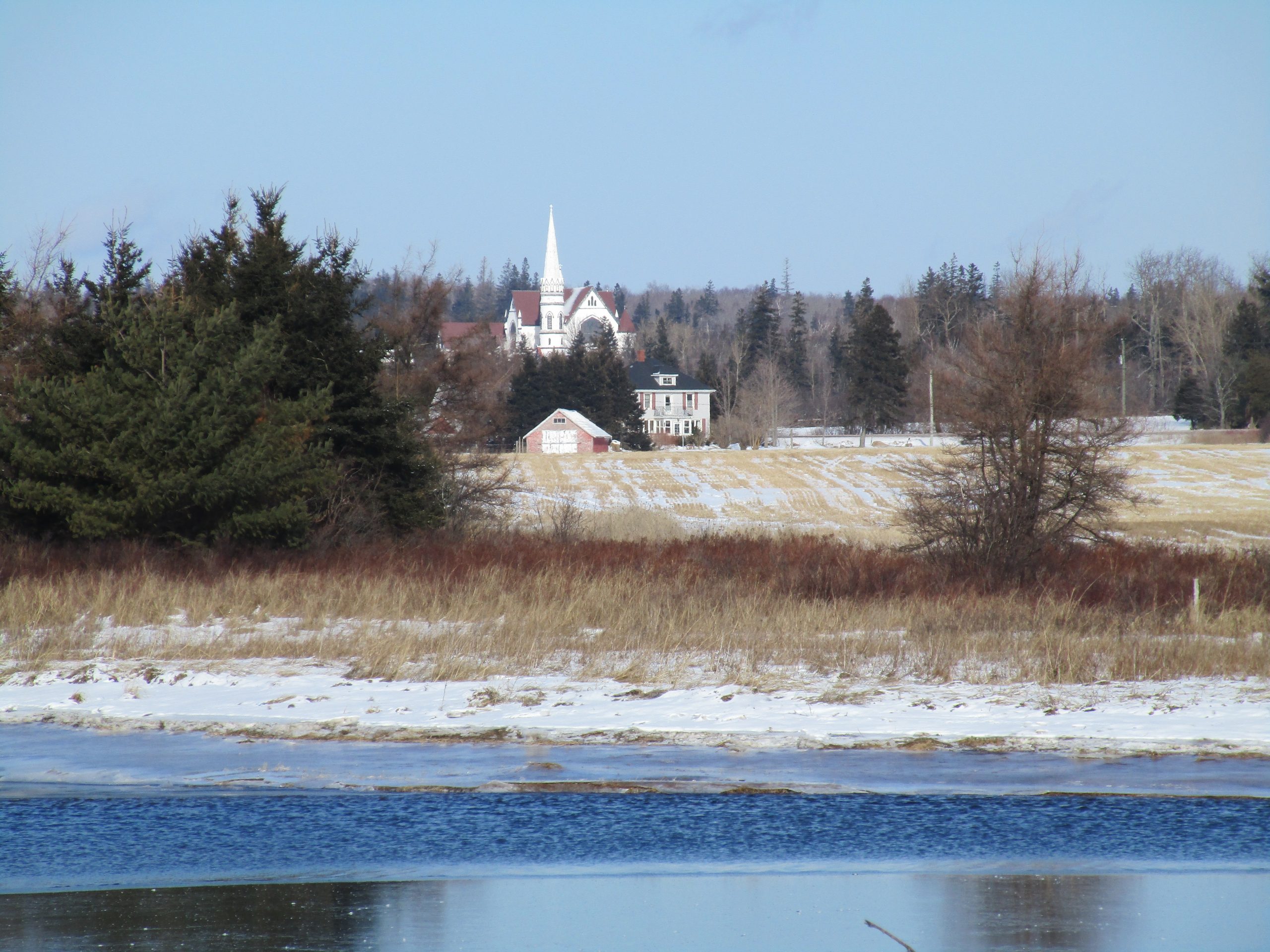
This cemetery is the final resting place of the parishioners of a Roman Catholic church that had once stood on the opposite side of the Easter Road. This church was built around 1812 and was used until 1842, when it was hauled across the frozen Malpeque Bay to what is known today as Summerside. After that, parishioners worshipped on a hill about a kilometre-and-a-half inland in two successive churches: St. Mary’s of the Pines and St. Mary’s. The second was built with wood milled and donated by the Tuplin family, and it still stands today.
A black pickup truck rolls down Easter Road and parks behind my car. A man crosses the field toward me. He has lines on his face and a grey moustache. My second guide.
He and I take in our surroundings. Across the white fields, about a kilometre-and-a-half away, St. Mary’s white paint shines in the sun. My guide points out where the general store and the school used to be. In the opposite direction, the white, frozen, barren Malpeque Bay stretches out in front of us, almost a continuation of the white, frozen, barren fields around us. The idea of “community” takes on a concrete form. For those buried here, and for those who lived here for a few generations thereafter, their community was once all within view. It was once all within reach. The water was once an integral part of it.
I climb in my guide’s truck, and we follow the Easter Road to the shore, which was once a hub of activity. Farmers built docks along this coastline for loading produce onto ships for export. They had small boats that they used to fish oysters in the summer. In winter, they set up mud-digging machines on the ice to drag the river bottom for the decomposing remains of the oyster and mussel shells. They then applied this “mussel mud” to their fields as a fertilizer. Travel to Summerside was a matter of crossing the water in the summer or the ice in the winter, sometimes with a church in tow.
A whale once washed up on this shore when I was a kid. Its bloated, grey, decomposing body lying on the red sand is my only memory of this place.
There is a twisted cottage to our right, buckling in on itself. One of Fiona’s victims. To our left, we walk past buildings spared by Fiona and through a hedgerow of trees. On the other side, my guide points to a C-shaped indentation in the shoreline. The surging waters of the Bay took a ten-metre bite out of the coastline here in September.
We walk back towards my guide’s truck. I stop for a moment, standing on the red clay deposited by the storm surge. I turn and look at the Bay. It is open and flat. There is nothing between me and the wind now. It whistles in my ear and reaches the skin on my arms and legs through my insulated clothing. The air temperature has dropped another five degrees. I pause, picturing myself out there on the open surface of the ice in a horse and sleigh.
I turn from the shore, climb back in my guide’s truck, and we leave.
It’s 12:45 P.M. I turn right off the MacLellan Road onto the Hamilton Road. After one-and-a-quarter kilometres, I turn right again onto the Clermont Road and drive for almost two more kilometres. I reach a bridge, the second of two that cross the Indian River. On either side appears an intermediary section of the river, between the mill site and the shore at the end of the Easter Road.
I pass over a bridge and reverse into a nearby lane. I walk on the side of the road back in the direction from which I came, leaving the sole set of footprints on the sand-covered snow, a mixture of brown and white. A car whooshes by heading the opposite way. I reach the bridge and peer through some wind-beaten brown brush to see the water. Much of it is a blue mirror; the rest is white ice.
Before Contact with Europeans, hundreds of Mi’kmaq once lived along these shores. They fished in the river and hunted in the surrounding forests. The Mi’kmaq continued to live here until the 1930s or 1940s: some stayed here year-round, while others came across Malpeque Bay from Lennox Island to spend the winter. They helped the farmers of the area with cutting wood, making hay, and harvesting grain and potatoes.
I leave the soft roadside snow and shuffle across the hard, black-and-white Clermont Road into another field. The ground is frozen underneath my boots, the snow a fine white powder. Small circular prints form a dotted line ahead of me. I am not the first one here today.
The river’s edge is lined with green spruce trees and tangles of brown brush. There is an opening a few metres ahead, and I walk toward it. I find a mound of brown earth partially covered in white snow. It is about two metres high, three metres wide, and frozen solid. I climb it. Below me, the paw prints continue along the snow-covered shore. Beyond lies the blue water of the Indian River. In the distance, the white, conical tower of St. Mary’s glistens in the sun.
Close to the riverbanks, the water is flat and reflects the surrounding trees. About fifteen metres from the shore, a line of moving water about five metres wide has a rougher texture and a darker blue colour than what surrounds it. My eyes trace this corridor of water back to its source. It flows from the other side of the bridge. It passes through a grey concrete opening underneath the bridge shaped like a square, upside-down “U.” The “U” is about five metres wide with a wall dividing it into two halves. There is about a metre of clearance between the water’s surface and the bridge’s concrete substructure.
It’s time to go home. My parents’ place is a couple of kilometres upstream, past the bridge. I picture myself paddling a canoe upriver toward our house. In my mind, I make it as far as the bridge before angling my canoe sideways, frustrated at having my passage through denied.
Instead, I retrace my steps across the frozen field toward the road. To get home from here, I guide my car along the roads that box the river, retracing the four-kilometre detour I took earlier. The shore and the river recede from view.
Until about seventy years ago, those who lived in Indian River relied on the water for their survival and prosperity, whether at the shore or further upstream. This relationship with the water has since changed.
The water has become an afterthought, a distant and irrelevant backdrop to what occurs on land. First with trains and then with automobiles, we have come to travel through the Island’s interior, far from the shore. We cross or go around rivers, catching bits and pieces but never knowing them fully. Like me, many Islanders can grow up very close to the water without it ever being a significant part of their experience. Like me, many can grow up without knowing the edge—the place where the land and the water meet.
Today, I found the edge, the one that’s been there the whole time.
And now our relationship with the water has entered a new phase. We have drifted further from working with it. It is now a threat. It surges over our land, tearing gashes out of the shore. The wind picks up over the open water and knocks over trees and buildings inland.
The edge has found us.