Illustrated Historical Atlas of the Province of Prince Edward Island

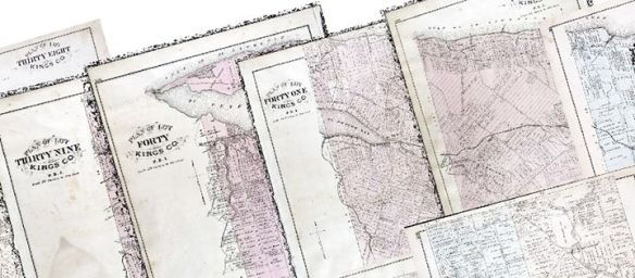
The Illustrated Historical Atlas of the Province of Prince Edward Island, colloquially known as Meacham’s Atlas of 1880, was one of the first attempts to map PEI in its entirety. A whole host of information can be found within the atlas; from detailed maps of each of the lots on the island – down to the individual houses, to realistic drawings of prominent citizens and their properties. It is a dream resource for any Island historian!

The Meacham’s Atlas maps before mosaicing.

For us at the GeoREACH lab, the atlas represents yet another opportunity to compile data on energy usage on the island during this period. We can see in the atlas the individual lots that compose our island even to today, each with personalized property information. The cartographers went so far as to outline the individual houses, barns, other infrastructure and property owners for each lot.

The Meacham’s Atlas maps after being mosaiced.

An important step in gathering the data from Meacham’s Atlas was to centralize all the available rasters (individual images) to a single resource. As all the lots were created independently, they would have to be stitched together into a single, geographically accurate map in a process formally known as mosaicing. This is why we have made, using GIS, a comprehensive mosaic of all the lots to easier represent this information.

The building points displayed over the entirety of Prince Edward Island.

Beyond that, we also entered data points for the over 16,000 buildings indicated on the map. Though it is still a work in progress, it is now available to be explored. You can adjust the different layers through the content window to look at churches, houses, mills, or schools, or can zoom in to a region you know well to see what it looked like in 1880!

Click here to explore the map.

The Kestrel

“The Kestrel or Sparrow Hawk is about the size of a Robin, and is the only small hawk which has a shade of chestnut-red in its tail feathers. Reed truly says that it has ‘bright colors and odd markings.’ It is so handsome and at the same time so evidently harmless, that it has escaped much of the destruction aimed at its larger companions. Another point in its favor is its ability to adapt itself to its environment: it is equally at home in the pasture lands of the east and the forests of other regions.

“The Kestrel feeds principally on mice, large insects, frogs, and snakes. At times it attacks birds and may kill jays, quail, and other birds as large as itself. It may visit towns where sparrows abound, whence the name ‘Sparrow-hawk.’ Dr. Taverner, however, thinks that a more appropriate name would be “Grasshopper Hawk.” (And he notes that when taken from the nest young, this little falcon is easily tamed.) Scientists have examined 291 stomachs and found that birds were killed and eaten only in the winter when insects are not available. “It is obvious that the Sparrow Hawk is beneficial and should be protected.” 

“Kestrel or Sparrow Hawk. AOU 360. Summer Resident- List, 1916. One observed at Alberton, 1937.

“Adult Male: Head slaty blue, crown rufous; face pattern black and white. Black rufous with or without black spots or bars. Wings blue gray; tail rufous-red with a wide sub-terminal black band and a narrow white tip. Underparts creamy white to buff, a few black spots or none. 

“Female: Head and face like male; black wings and tail rufous, barred black; underparts more or less dark brown and streakedImmature birds resemble adults. Length of adult 10.5 inches.”

Source

August 8, 1956

#OnThisDay in 1956, the author of Ellen’s Diary talked about Prince Edward Island’s summer coming to a close, mechanization in farming, and how some Island farmers were still holding on to traditional methods.

PEI potato field

“Now the clouds we send our dreams sailing upon are August’s. They moved quietly today on a sunny sea of blue above the gleen-clad hilltops, great liners of smokey down, with a bit of austerity in their rigging an ominent edge of Autumn, it seemed. But not yet are we content to let Summer go. ‘Once the haying’s over’ one of the family said today noting the blackbirds in a flock gleaning tidbits of insects in a shorn hay hayland, ‘well, they days are noticeably shorter by then’ and her smile was wistful, ‘whether or not we like to acknowledge it, the heart of the summer is spent.’

‘Folks can commence then to store their fuel-wood’ another offered, thoughts evidently going on to envision the deserted lawns and verandahs, the closed doors, and hearthfires once more kept bright.

Today was still summer. We kept jealously every hour sunny and warm and breeze-fanned. It was pleasantly warm for the workers, for Rob in the field building the great loads of hay, for the younger farmer in the closeness of a mow at the storing. 

‘There’s no exceptional call for cooling drinks this haying.’ Jeanie said. Not a hot day- just warm, this one. And in the fields the hay making to a nicety for the farmers. And away in far places of the countryside, a dreamy haze of season veiling the hills.

…‘With machinery now to help, the haying is certainly much easier done than once,’ we commented remembering more toilsome days at it though nonetheless sweet. ‘The changes there have been!’

‘We still have an old mare in the lift- no change there.’ another chuckled. No, no change there. The hose still beats out a regular path along field or yard, retarding so far the march of progress at Alderlea it is true but keeping for our sake this nice item of old at the haying.”

July 25, 2019

Hay saving is an age old tradition that many farmers employ in the stocking of fodder for their livestock, as seen in this entry of Ellen’s Diary dated from July 25, 1958. The process of saving hay involves cutting long grasses, then drying them, and storing them until your other fodder stocks are depleted. In the 1950s, saving hay was still an arduous task. It took a great amount of time and injuries were commonplace. However, Ellen’s time period was significant for island farmers, as many started using more efficient and easier to use tractors instead of horses to aid in their harvest. This diary entry helps illustrate this important transition from horses to tractors.


“Gathering in the grain 1906” from Earles Picture Restoration Prince Edward Island.

“’And take your time!” James called after the help going on ahead in the truck to the field and the saving of hay this morning.

“He was harnessing the team for the rake at the time, buckling an end of the double reins to a bit, and adjusting the others in turn.

“’It’s the haste, Ellen”, he commented “that brings the accidents. There’s never a haying that there isn’t misfortune somewhere – falls and broken limbs, and other hurts. And there’s also those that come from poor gearing. I like to have everything in good shape, down to the smallest detail of it. They say ‘An ounce of prevention…”

“’!… is worth a pound of cure” we finished with a chuckle.

“’Well” he nodded, “there never were truer words than those when applied to the haying. A block half secured gives away, an old swing on the lift breaks or poor harness gives… and too late folks are in difficulties!”

“’You’ll ride?” we said watching him gather up the lines.

“‘Oh no, I’ll walk. The exercise will be good for me. I’ll be seated on the rake long enough!’

“Granddaughter, by choice, and with her assistance much appreciated, managed the horse in the lift this afternoon, enjoying it much.

“…Mack a steady little fellow, and with an adult close by, was allowed to drive the tractors on a level field, well pleased at this responsibility and his elders that he did it so well. So with all the help there was a great saving of hay, and by this evening first barns were full.”

Glen Property Visit, July 2019

An area of Bill Glen’s woodlot. The nut orchard is slightly visible in the background.

On Wednesday 18 July, some of the GeoREACH Lab team members took a trip into the field (literally) to visit Bill and Elizabeth Glen’s land in the Bonshaw area of Lot 30, Prince Edward Island. Bill and Elizabeth are well known in PEI genealogical and historical circles, and Bill was formerly a forester with the PEI Provincial Government. He now serves as a forest and woodland consultant, and he co-authored a chapter with Josh MacFadyen in the University of Calgary Press collection on Historical GIS Research in Canada. The Glens have been on their property since the early 1980s, and they were able to provide some real insight into how the land has changed over the last forty years, including how they managed the forest, fields, and hedgerows!

Bill Glen, GeoREACH Lab Director Dr. Josh MacFadyen, and research assistants Nolan Kressin and Abby Craswell.

The team has studied Lot 30 extensively using aerial photos and historical maps on GIS. We were excited to explore the real area that we have been examining from above for the last several months. It reminded us that our research is much bigger than just a computer screen! We could see the changes that have occurred in the land since the aerial photos that we are currently studying were taken in 1968, before the implementation of the Comprehensive Development Plan (for more on that see this post). Some of these changes include hedgerow planting, the appearance of new homes, and a new nut orchard on the property.

Research assistants Nolan Kressin, Nick Scott, and Abby Craswell (L-R) in the field.

While on this excursion, we learned about hedgerow and woodlot composition, as well as the importance of biodiversity and climate change adaptability in wooded areas. White spruce (what we use to plant most of our hedgerows) is incredibly vulnerable to slight shifts in climate! Bill also showed us a hydraulic pump that dates back to 1890, which he still uses to pump water to the tank for his nut orchard. The GeoREACH team would like to thank Bill and Elizabeth Glen for having us to their home and sharing their knowledge of land-use change on Prince Edward Island.